About five months later, the August 23 Virginia Earthquake precipitated the emergency shutdown of the two pressurized light water reactors at North Anna Nuclear Power Station (NPS) roughly 35 miles from my home. According to the U.S. Geological Service, the station is located at a distance of only 8 miles from the quake's epicenter and 20 miles from a quaternary fault zone. Seismologist Dr. James Martin of Virginia Tech. gave a comprehensive interview on the quake to Beverly Amsler aired on WVTF Radio IQ's Evening Edition for Nov. 22, 2011. The events made me wonder what a radiological emergency similar to that in Japan would entail in the U.S.
 |
When a utility company applies to the U.S. Nuclear Regulatory Commission (NRC) for the license to build a nuclear power reactor, an emergency plan for the eventuality of a radiological accident must be submitted. The plan must conform to federal regulations (10 CFR § 50.47 Emergency Plans). Dominion, the operator of North Anna NPS, is planning to construct a third unit on the station's premises and has hence developed such plan.
Examining Dominion's "North Anna 3 Combined License Application, Part 5: Emergency Plan, Revision 0 November 2007", reveals that much of the responsibility for the immediate decisions to be taken in the course of a severe reactor accident rests with the station operator, that is, primarily on the shoulders of the station's Emergency Coordinator (page II-1 of the proposed emergency plan). This person is instructed to collect information about the radioactive contamination monitored in the surroundings of the station, estimate the source term, that is the amount of radioactivity released from the failed reactor, determine the prevailing winds and precipitation, dispersing the radioactive matter, and constantly keep the relevant local, state and federal agencies up to date about the evolution of the accident.
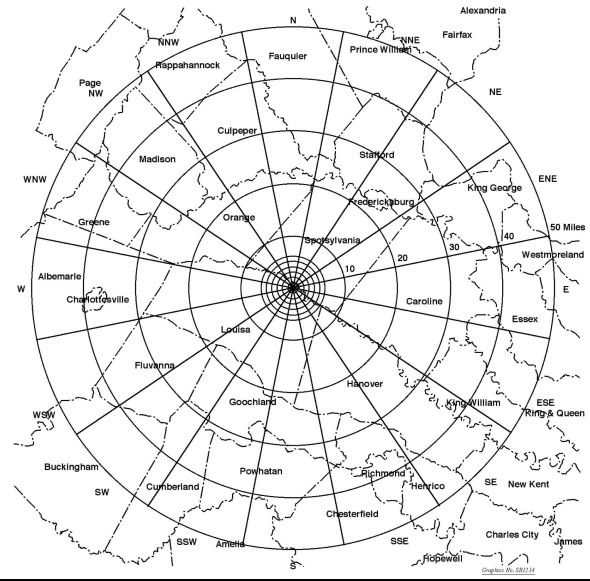 |
| Map showing county lines and distance radii of Emergency Planning Zones proposed for North Anna NPS Unit 3 (source: Fig. I-2; Dominion). |
Precise recommendations to the public depend on the source term and the progression of the plume in which the radioactivity is dispersed. The anticipated immediate protection measures are contingent mainly upon the distance from the power station. Radii of action are drawn (see drawing above). In addition to the protection of station personel (site emergency), the greatest concern lies with the safety of residents living within a 10-mile radius around the station, for whom precise instructions for health protection, evacuation and shelter have been planned (general emergency). This area is designated as the Plume Exposure Pathway Emergency Planning Zone. Radio stations periodically test emergency alert announcements (texts and further details can be found in the Commonwealth of Virginia Emergency Alert System Plan). Sirens alert residents to tune into local radio and TV stations for detailed announcements. Residents living within the 2 mile perimeter around the stricken NPS and within 5 miles straight downwind, including a margin on both sides (keyhole pattern), will be asked to evacuate immediately. Other residents within the 10-mile perimeter will be asked to stay indoors (NRC Backgrounder on Emergency Preparedness at Nuclear Power Plants).
The plans for residents beyond 10 miles depend on the amount and the duration of the release of radioactive matter from the reactor. The 50-mile radius encompasses the largest territory taken into consideration in the station's emergency plan. This area is designated as the Ingestion Exposure Pathway Emergency Planning Zone. Dominion set up a series of monitoring stations around the station. Near-real time ionizing radiation measurements available to the public within 100 miles from North Anna NPS, are disseminated by only two Radnet stations: one in Richmond and one in Harrisonburg, Virginia.
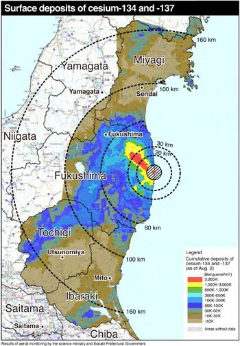 |
Local wind and precipitation mainly dictate the shape of the plume in which the radioactivity is transported and disperses. To provide an example the color-coded radiation map above shows the overland plume-shaped radioactivity dispersal reconstructed with computer models from radiation monitor recordings after last year's severe accidents at Fukushima Dai-ichi NPS.
 |
In a hypothetical release at North Anna NPS resembling that of Fukushima, local weather conditions could produce a similar plume heading in a different direction. Wind speed and direction recorded at Louisa County Airport (see above) a few miles from North Anna NPS suggest that prevalent local winds blow on average from South/Southwest to North/Northeast. The plume would most likely progress toward Northern Virginia. Dispersal to the South toward the Richmond Metropolitan Area represents the second most probable direction.
The distance over which the plume eventually extends depends on the amounts of radioactivity released, the altitude of the release, wind speeds affecting the release, and precipitation. In Japan, the plume barely impacted Fukushima City, 35 miles from the nuclear reactor accidents. Note, however, that prevailing winds blew much of the airborne radioactive material out to sea.
Dominion's proposed emergency plan is most concerned with immediate impact after a severe radiological emergency. The long-term evolution of a wide-spread radioactive contamination can only be extrapolated from experiences after the Tchernobyl reactor disaster in 1986 and the ongoing contamination and clean-up around Fukushima Dai-ichi NPS. Regardless of the uncertainties, it seems only prudent to consult our local Radiological Emergency Plan, if we live within the 50-mile ingestion zone around a nuclear power station.
Acknowledgement
I thank the members of the simplyinfo.org discussion group for their cogent input, without which this post would not have been possible.
Relevant Sources


